


What area of rightfull land in Tajikistan is currently in the possession of Kyrgyzstan? 145,000 ha, 211,000 ha or 420,000 ha? What legally substantiated documents does Tajikistan rely on in the border dispute with Kyrgyzstan? What do the “documents of 1924-1932” mean and why are they the only basis? What are the “documents of 1958-59”, and what is the essence of the “documents of 1989”? What are the arguments of the Kyrgyz side and their legal significance? How did the Constitution of the USSR divide the borders between the union republics? On the basis of what materials are the lands of Tajikistan at the disposal of Kyrgyzstan? Which areas include the so-called? “Disputed territories”?
Below are detailed answers to the questions posed about the legal foundations of the position of the Republic of Tajikistan in the border dispute with Kyrgyzstan.
***
The border dispute between Tajikistan and Kyrgyzstan, which has been going on for almost a hundred years, has become complex and tense in recent years. Examination of the positions and statements of the parties, an assessment of the political and information processes accompanying the problem show that this issue is not only at the stage of settlement, but also in the process of escalating tension. The accession of states and international organizations to mediation in conflict resolution HAVE MUCH MORE INCREASED THE POSSIBILITY OF ITS TRANSFORMATION FROM A LOCAL ISSUE INTO A REGIONAL AND INTERNATIONAL DISPUTES.

The experience of resolving ethnic conflicts in the post-Soviet space shows that in most cases the emergence of Eastern and Western “mediators” leads to a larger and more prolonged spread of such crises.
Although Tajikistan at all levels and stages declares its commitment to a peaceful solution to the problem, the prospects for the current process indicate that now our state and society should be ready for more difficult situations. With such forecasts and prospects, along with serious political, military and informational preparation, one of the most important needs is awareness of the essence of the issue, the reality of the position and interests of the Republic of Tajikistan by various sections of society.
Monitoring of the information space and regular contacts with representatives of the population show that most citizens have a high sense of patriotism and are ready to defend the borders of their country, but do not have reliable information about the essence of disagreements, the causes of a conflict situation regarding interstate borders and the details of the position of the Republic of Tajikistan on this issue.
With this in mind, in order to help raise public awareness in this direction, a rigorous analysis of the historical and legal foundations, existing contradictions, arguments, facts, documents and maps provided by the Tajik side to substantiate its position is presented. (The political, economic, social, cultural, civilizational and geographical aspects of this issue are considered by the author in other articles).
***
EXPLANATION OF THE REASONS THE BORDER DISPUTES BETWEEN TAJIKISTAN AND KYRGYZSTAN
The essence of the border conflicts between the two neighboring states is that, according to official documents defining the borders, today the Kyrgyz Republic has 211,000 hectares of land plots of the legal territory of the Republic of Tajikistan. Such data were announced on September 23, 2022 in a statement by the Minister of Foreign Affairs of the Republic of Tajikistan at the UN General Assembly. The essence of the border conflicts between the two neighboring states is that, according to official documents defining the borders, today the Kyrgyz Republic has 211,000 hectares of land plots of the legal territory of the Republic of Tajikistan. Such data were announced on September 23, 2022 in a statement by the Minister of Foreign Affairs of the Republic of Tajikistan at the UN General Assembly.
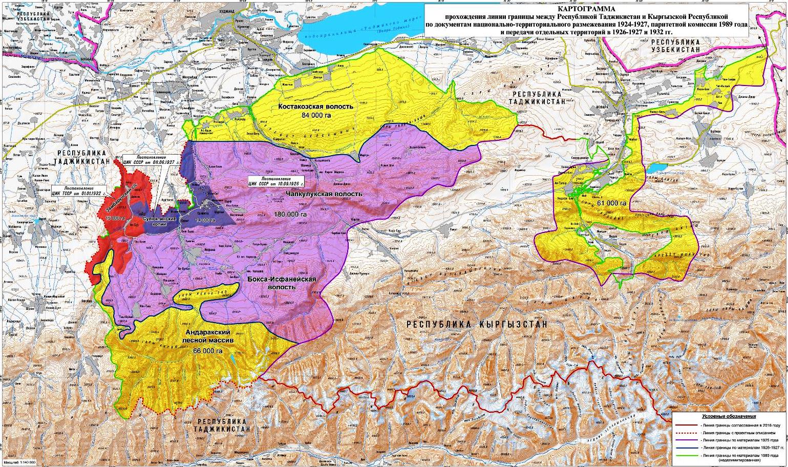
According to official data, these lands are referred to as “disputed plots”, occupying 84,000 hectares of land in the Bobojon Gafurov district (mainly in the Khistevarz (Kistakuz) rural communities about 66,000 hectares in the Kuhistoni Mastchokh district (Andarak forest zone), 61,000 hectares – in the territory of Isfara (in the rural communities of Surkh, Lakkon, Chilgazi, Shahrak, Chorkuh and Vorukh) as well as some other small areas in the Jabbor Rasulov and Spitamen districts.
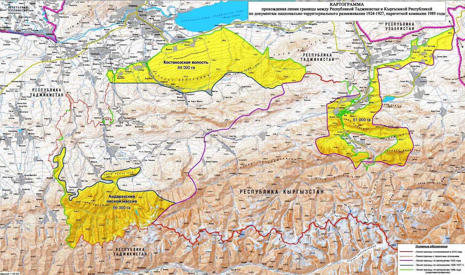
For an accurate representation of the scale and geographical latitude of 211,000 hectares, or 2,110 square kilometers of land, we note that this is approximately equal to the total area of the cities of Isfara, Konibodom, Khujand or several TERRITORIES OF DUSHANBE CITY with its new administrative units. That is, we are talking about such a huge territory! Compared with other states, the lands seized by the Kyrgyz Republic are equal to the area of Luxembourg, almost twice the size of the territories of Singapore or Bahrain.
These lands, which are legitimate territory of Tajikistan, have been developed by Kyrgyzstan over the past 90 years in various ways, and are currently being actively used.
The fact that these parts of the territory of Tajikistan was also known in the Soviet times.
In this regard, administrative and domestic disputes periodically arose here. But since both republics were part of the Soviet Union until 1991, internal borders were not considered interstate, and the legal dispute about their revision was not relevant.
With the acquisition of state independence, the legal and political status of the border line completely changed, and the need arose for the final legal registration of the borders between the two independent states. Therefore, Tajikistan specified its state borders on the basis of official documents defining the border division between states, and DEMANDS KYRGYZSTAN TO RETURN OWN LAND.
In general, to date, more than 200 meetings and negotiations at various levels have been held between the Republic of Tajikistan and the Kyrgyz Republic on this issue, a draft description of the passage of the Tajik-Kyrgyz state border line with a total length of 606.79 km, which is about 62%, has been prepared. However, the Kyrgyz side refrains from signing and formalizing the agreements reached.
The readiness of Tajikistan to sign them was voiced in the speech of the President of the Republic of Tajikistan at a meeting with residents of the Vorukh rural community of Isfara city on 04/09/2021.

The remaining part (39%) of the border line remains a complex and uncertain situation. In these areas, incidents regularly arise between residents on domestic issues, for the use of drinking and irrigation water, housing and agricultural land, pastures, roads, bridges, crossings, power lines, natural resources and cemeteries, sometimes reaching bloodshed.
Non-compliance with bilateral agreements on the status and use of specific border areas and facilities, signed in recent years, complicates the situation, making it more unstable. A recent example is the withdrawal of Kyrgyzstan from the 2009 land lease agreement in 2021, effectively undermining mutual trust.
In addition, in 1999, the Kyrgyz side established a new Batken region covering most of the “disputed territories”. With the adoption of the law “On the special status of the Batken region” (No. 113 of September 10, 2021), the named territory has practically turned into a special military-defensive region, which gives a military-political tinge to domestic and social conflicts in the border zone. Article 14 of the law provides that in this region (i.e., on the legal lands of Tajikistan), the number of the Kyrgyz population and settlements will purposefully increase through the provision of various economic and social benefits.
And the new law of the Kyrgyz Republic, adopted on October 20, 2022, provides for the general arming of the inhabitants of these illegal settlements. Such situations, instead of helping to solve problems, increase the likelihood of ordinary incidents escalating into another large-scale armed conflict.
This is the main essence of the border dispute between the two neighboring states.
2. WHAT IS THE “OFFICIAL DOCUMENT DETERMINING THE INTERSTATE BORDER”?
One of the controversial points that have arisen in the border issue between Tajikistan and Kyrgyzstan is the discussion about documents. The significance of this issue lies in the fact that it is the documents that ALLOW to SPECIFICATE THE DIRECTION of the negotiations, to determine the validity and Principe of their position to the parties. It is the documents that make it possible to reveal the historical truth, to come to an agreement and concrete conclusions. That is, it is impossible to conduct productive negotiations and restore justice without a “confirming document”. However, the current process shows that the parties have significant disagreements on the use of documents.
Official documents adopted in a UNILATERAL ORDER, but not passed the necessary procedures by both states, cannot serve as a basis for determining interstate borders. This is a legally justified, principled and rational position of the Tajik side.
The practical need for Tajikistan’s persistence is based on the fact that most of the “disputed land” in the use of Kyrgyzstan (the same 211,000 ha) has been leased out over the past 90 years through acts such as the interaction of ordinary citizens or local officials ( 1), exchange of land resources between collective farms and state farms (2), oral agreements of the leaders of rural communities , districts and regions (3), decisions of sectorial ministries and departments (4), purchase and sale of land (5), protocols of joint commissions (6), official interdepartmental or interstate lease (7), etc. That is, these lands were assigned to the Kyrgyz at different levels by unauthorized individuals and legal entities. The practical need for Tajikistan’s persistence is based on the fact that most of the “disputed land” in the use of Kyrgyzstan (the same 211,000 ha) has been leased out over the past 90 years through acts such as the interaction of ordinary citizens or local officials ( 1), exchange of land resources between collective farms and state farms (2), oral agreements of the leaders of rural communities, districts and regions (3), decisions of sectorial ministries and departments (4), purchase and sale of land (5), protocols of joint commissions (6), official interdepartmental or interstate lease (7), etc. That is, these lands were assigned to the Kyrgyz at different levels by unauthorized individuals and legal entities.
One of the “arguments” of the Kyrgyz side in this dispute are some administrative and local acts on the use of part of the land. But the advantage of the position of Tajikistan is that none of these documents, which were signed between individuals, farms, districts and land use departments, did not go through the necessary legal procedures both in the Soviet period and after gaining state independence. That is, IT IS NOT RECOGNIZED AS AN OFFICIAL DOCUMENT DETERMINING THE STATE BORDER BETWEEN TAJIKISTAN AND KYRGYZSTAN.
Therefore, although such materials are based on acts on land management, temporary use of sites, none of them has the legal force of an interstate document. Therefore, it cannot be used as a basis for changing and defining boundaries.
This is the essence of Tajikistan’s position on the issue of “supporting documents”.
However, the Kyrgyz side is not interested in such a formulation of the issue or recognition of this reality, since it is the approach to the problem from a legal point of view that proves that these lands belong entirely to Tajikistan. Thus, the Kyrgyz side presents as a basis various acts of various periods concerning the exchange of land between farms (1), temporary use of land (2) or the creation of organizations (3). At the same time, Kyrgyzstan seeks to give legal justification to the lands it has at the expense of Tajikistan.
The contradiction is that:
Firstly, none of these acts has the status of an official document defining the state border between the two countries.
Secondly, if Tajikistan agrees to such a “justification” or a way to resolve the issue, then most of the “disputed lands” will go to Kyrgyzstan. Such a situation does not correspond to either the historical truth, or the legal basis, or the national interests of Tajikistan.
This is the crux of the dispute between the two countries over the use of documents and regulations.
3. HOW DID THE USSR CONSTITUTION ESTABLISH THE BORDERS BETWEEN THE REPUBLICS?
The legal basis for state recognition of documents defining boundaries is that they must be adopted and approved within the framework of the provisions of the Constitution of the USSR. Because in order to change the state borders of the republics that are part of the Union, the Constitution of the USSR first required the consent of these republics, and then – the adoption of an appropriate decision by the highest state Soviet power. Only in this case, the act could receive the status of an official document defining the border between the republics. This requirement was enshrined in all the constitutions of the USSR adopted in 1924, 1936 and 1977, which is an indicator of its importance.
In particular, in the Constitution of the Soviet Union, adopted on January 31, 1924, the regulation of changing the borders between the republics belonged exclusively to the competence of this state, and it was determined that “WITHOUT THE CONSENT OF THE ALLIED REPUBLICS, THEIR BORDERS CANNOT BE CHANGED.
4. SUPPORTING DOCUMENTS OF THE TAJIK SIDE, THEIR LEGAL STATUS
In negotiations on the border with the Kyrgyz Republic, the Tajik side relies solely on documents that have passed all stages of interstate procedures and are recognized as defining the border between two states. Therefore, Tajikistan appeals to the “DOCUMENTS of 1924-1927, 1932 and 1936”. The basis and necessity for this is as follows:
1. “Documents of 1924-1927, 1932 and 1936” are the only package of documents in which the state borders between Tajikistan and Kyrgyzstan are officially confirmed.
2. These documents are the only ones that have fully passed all the established constitutional intra-republican and state procedures for determining the boundaries between the republics within the USSR and have passed legal formalities.
3. During the period of the Soviet Union and after gaining state independence by Tajikistan and Kyrgyzstan, that is, from 1932 to the present, not a single document defining the state border between these two states was adopted in the prescribed manner at the interstate, republican and state levels of the USSR.
4. If the documents of 1924-1927, which are founding for the Central Asian republics, are ignored, THE POSITION OF THE BORDERS WILL THEORETICALLY RETURN TO THE HISTORICAL STATUS BEFORE THE FORMATION OF THE SOVIET UNION. That is, then we can talk about the borders of the Emirate of Bukhara and Tsarist Russia, and even the khanates of Khiva and Kokand.
In this case, both parties lose their subjectivity in border negotiations, and the course of the process will completely change.
Thus, the “documents of 1924-1927 and 1932”, that Tajikistan focuses on, are the only necessary and legitimate in determining the state border between two neighboring states.
WHAT IS THE ESSENCE OF THESE DOCUMENTS?
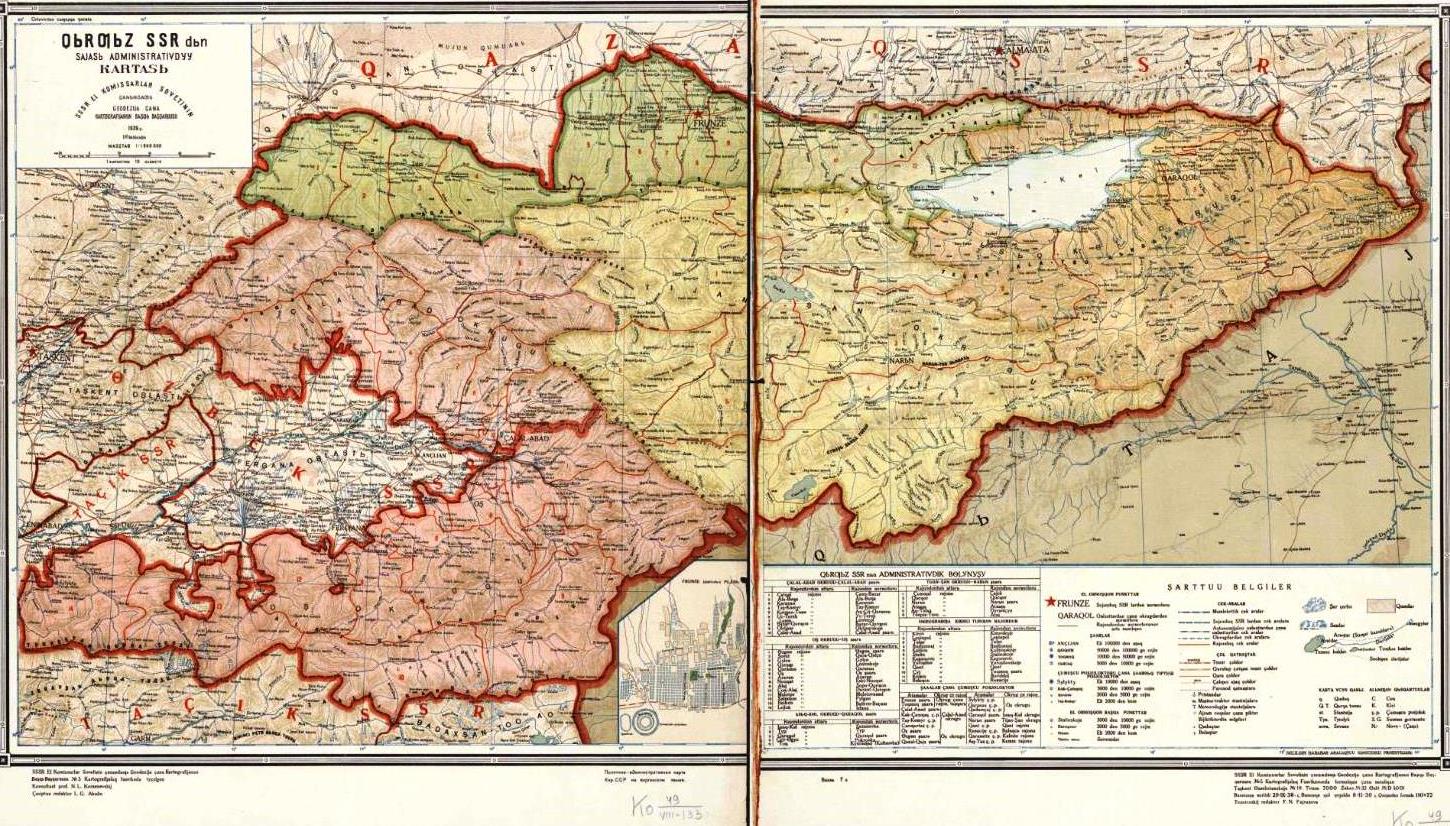
Under the “documents of 1924-1927 and 1932” are meant documents on the national-territorial delimitation of Central Asia in 1924-1927 and their final approval. It is known that the Kyrgyz Republic was part of the RSFSR as an autonomous region until April 15, 1927, and as an autonomous republic until December 5, 1936. Therefore, when receiving the status of a union republic (in 1936), this republic was formed within the same borders approved in 1924-1927 and 1932.
A careful study of historical and archival materials indicates that on November 24, 1924, the “Central Asian Liquidation Committee” was created in order to implement the plan for national-administrative division and the creation of new republics, which until March 17, 1925 completed the technical work and preparation of documentation for their division.
Based on this, on September 29, 1925, the Presidium of the Central Executive Committee of the Uzbek SSR, to that Tajikistan was an autonomous republic, approved the state border between the Uzbek SSR and the Russian Soviet Federative Socialist Republic, which at that time included Kyrgyzstan as the “Karakyrgyz Autonomous Region”. On November 9, 1925, the Presidium of the Central Executive Committee recognized and approved the border between the RSFSR and the Uzbek SSR in the same territories indicated by the committee. Thus, the division of 1924 passed all the established procedures and entered into force, securing their geographical location.

That is, the border between Tajikistan and Kyrgyzstan was formalized during their existence as autonomous units within Uzbekistan and the Russian Soviet Federative Socialist Republic. And part of the border in the Khujand region was formalized in 1929 during the period of its withdrawal from Uzbekistan. In this process, the borders of the Russian Soviet Federative Socialist Republic, and Uzbekistan did not change.
The decision regarding the Murgab zone was also finally approved in the process of creating the Central Asian republics. Along with the formation of GBAO, this region has been part of Tajikistan since January 2, 1925.
The statements of some Kyrgyz experts that “if we rely on the documents of 1924-1927, then Murgab was part of the territory of Kyrgyzstan” are completely unfounded. Despite this, it was in accordance with these documents that Murgab became an integral part of the Republic of Tajikistan, and this section of the border went through the relevant procedures at the level of the republic and the Supreme Legislative Body of the USSR. The question of Murgab, in accordance with the “documents of 1924-1927”, was finally resolved. When the Tajik ASSR left the Uzbek SSR in 1929, the Pamirs were renamed the Mountains – Autonomous Badakhshan Region as part of the Tajik SSR. Later, in the Constitution of the USSR of 1936, it was also enshrined that MABO was included in the Tajik Soviet Socialist Republic.
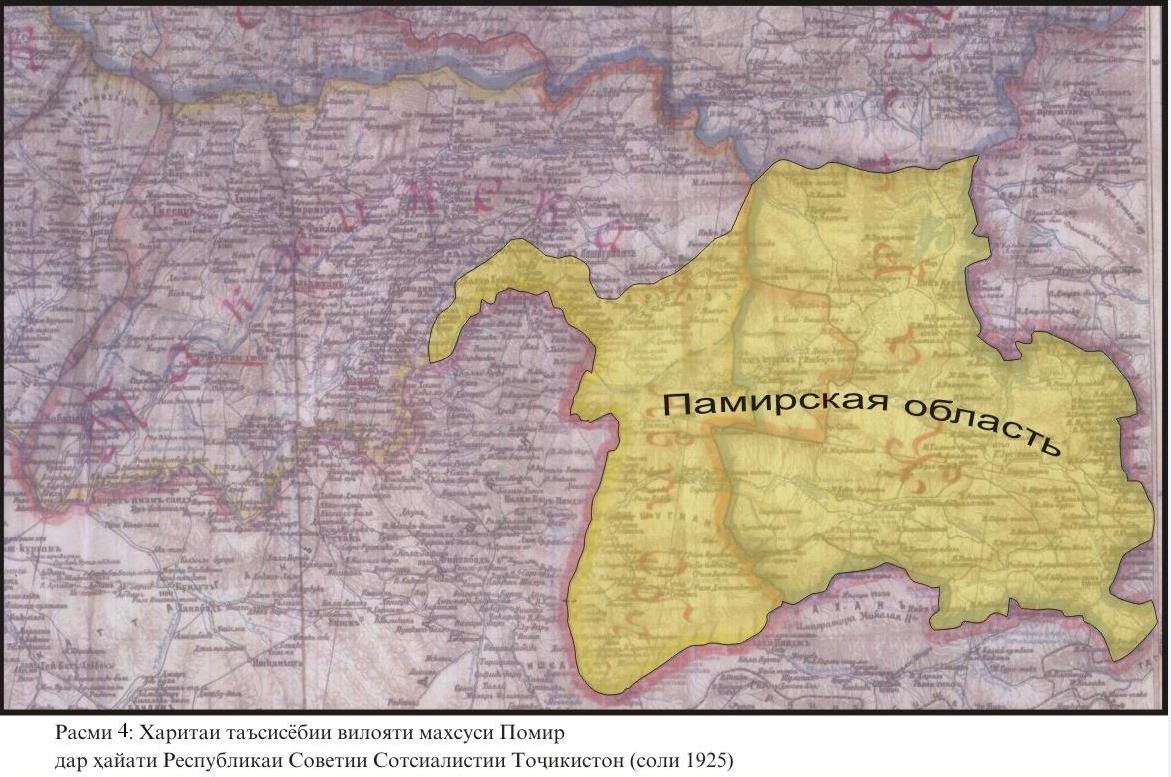
Thus, the belonging of a part of the Pamirs (MABO) to Tajikistan was finally decided on the basis of constitutional provisions and cannot be the subject of a division.
An important point is that as soon as the borders of the republics were approved in 1925, the Kyrgyz side (as part of the RSFSR) protested against the borders in Sulukta and Isfara. As a result of consideration of this issue, by the Decree of the Supreme Legislative Body of the USSR, Sulukta became part of the RSFSR (Kyrgyzstan), and Isfara remained part of the Uzbek SSR, of which Tajikistan was a part. That is, Isfara (including land up to Vorukh) also remained a part of Tajikistan.
Such a joint decision, reached with the consent of the parties, was finally approved on May 4, 1927 by the Central Executive Committee of the SSR.

Such a joint decision, reached with the consent of the parties, was finally approved on May 4, 1927 by the Central Executive Committee of the SSR.
Another fact that serves as supporting evidence of the true belonging of Vorukh to Tajikistan is the decision of the Council of People’s Commissars of the Soviet Union of 1947 on the approval of the borders between the Republic of Uzbekistan and the Kyrgyz Republic. On the official map published by the GUK of the USSR following the decisions of the Council of People’s Commissars, Vorukh is designated as part of the territory of Tajikistan.
The RSFSR and the Uzbek SSR, in full accordance with the legislation of the USSR of that period, established inter-republican borders, thereby putting an end to the issue of borders. This package of documents in the process of negotiations is called “documents of 1924-1927”.
Of course, documents, maps and archival materials indicate that after the official approval of the borders between Tajikistan and Kyrgyzstan (as part of Uzbekistan and the RSFSR) in 1925, at the request of the Kyrgyz side, several volosts and settlements were transferred to Kyrgyzstan at the expense of the legal lands of Tajikistan . In particular:
1. September 10, 1926 Bakso-Isfaninsky and Chapkuluksky volosts, with a total area of 180 thousand hectares.
2. June 8, 1927 Sulukta coal basin with an area of 14 thousand hectares.
3. On January 1, 1932, the territory of the Zamburuch locality, including the villages of Zamburuch, Zhar, Zhizgon and Chuyanchi with a total area of 15 thousand hectares.

Naturally, if there are official documents of the level of the Soviet Union on the transfer of these sites to Kyrgyzstan, the Tajik side will not make any claims.
5. ADDITIONAL EVIDENCE OF THE VALIDITY AND LEGALITY OF THE 1924-1927 DOCUMENTS
Some experts from neighboring countries and foreign specialists, commenting on the “documents of 1924-1927”, declare that they were adopted during the period when Tajikistan and Kyrgyzstan were part of the RSFSR and Uzbekistan. In particular, such a question is raised in connection with the fact that Kyrgyzstan became a union republic in 1936.
However, it should be emphasized that, according to the legislation of the Soviet Union, after the secession of Tajikistan from Uzbekistan and its transformation into a union republic in 1929, all approved documents of the border section were inherited by Tajikistan.

After secession from Russia at the end of 1936, the Kyrgyz Republic also inherited and officially recognized its borders as part of the RSFSR, that is, the division until 1927.

In addition, if the Kyrgyz side denies the legitimacy of the supporting “documents of 1924-1932” when determining the borders as a result of the mentioned decisions on the transfer of these volosts and settlements, then, following the logic, Tajikistan may raise the issue of their return. In this case, the territory of “disputed lands” will increase from 211,000 ha to 420,000 ha with the addition of 209,000 ha of lands of three plots. Therefore, the refusal of the relevant documents is not in the interests of the Kyrgyz side.
The border line between the two republics is also clearly indicated in the map attached to these decisions.
That is why, from the point of view of the Tajik side, the “documents of 1924-1927” are the only legitimate basis for determining the state border between Tajikistan and Kyrgyzstan.
A weighty proof of the legitimacy of the “documents of 1924-1932.” is that after the border conflict in 1989, at the request of the Council of Ministers of the Tajik SSR and the Council of Ministers of the Kirghiz SSR, in 1990 a special commission of the Supreme Soviet of the USSR was created to determine the border between the republics. Having studied this issue, the commission came to the final conclusion that only “documents of 1924-1932” can be recognized and used as defining the border between Tajikistan and Kyrgyzstan.
However, obtaining from the historical archives of the Russian Federation and the Republic of Uzbekistan additional documents of the border department at the time of the formation of these republics and materials of the special commission of the Supreme Soviet of the USSR in 1990, is considered one of the important tasks in the process of negotiations and determination of borders. Some experts from neighboring countries and foreign specialists, commenting on the “documents of 1924-1927”, declare that they were adopted during the period when Tajikistan and Kyrgyzstan were part of the RSFSR and Uzbekistan. In particular, such a question is raised in connection with the fact that Kyrgyzstan became a union republic in 1936.
6. AN ADMINISTRATIVE LINE OR
STATE BORDER?
(Clarification of the legal status of documents after 1932 referred to by the Kyrgyz side)
During the discussion, the Kyrgyz side refers to a number of documents prepared during the period from 1932 through 1991 and during the period of independence of the two countries. Some of these documents were developed as a result of local and administrative negotiations on the exchange and temporary use of land, and some – as a result of the work of various commissions to resolve border disputes. In order to solve emerging land use problems between the two countries, joint commissions have been established that are trying to resolve existing disputes.
While considering the friendship of the two peoples and the fact that they lived in the united USSR, in the course of the work of these commissions, some legal lands of Tajikistan were transferred to Kyrgyzstan for rent, for temporary use. However, the decisive point is that after 1932 and before the collapse of the Soviet Union, not a single document defining the state border was approved in the prescribed manner. Therefore, all materials used by Kyrgyzstan as documents defining the state border have no legal force.
The Kyrgyz side presents three packages of documents as arguments in border negotiations with Tajikistan, the validity of which is as follows.
- PACKAGE OF DOCUMENTS OF 1949:
These documents contain protocols and maps drawn up by bilateral commissions prior to 1949. The subject of their discussion is the registration of lands, which since the 1930s were periodically transferred by Tajikistan for temporary use to Kyrgyzstan. The main act is an official letter from the Council of Ministers of Kyrgyzstan to the Council of Ministers of Tajikistan dated 1949, in which the Government of Kyrgyzstan officially requests to annex specific sections of Tajikistan to its territory.
Therefore, the LETTER itself AND THE OFFICIAL REQUEST OF THE GOVERNMENT OF KYRGYZSTAN TO THE GOVERNMENT OF TAJIKISTAN PROVE THAT THESE LAND BELONG TO TAJIKISTAN, AND BY THIS LETTER KYRGYZSTAN ALSO RECOGNIZES THIS FACT.
However, the Council of Ministers of the Tajik SSR, in its official response, found such a provision contrary to the Constitution of the USSR (1936) and emphasized that changing the borders of the republics is the exclusive competence of the highest legislative body of the Soviet Union. In other words, Tajikistan rejected Kyrgyzstan’s request to transfer its lands. The package of documents of 1949 was not recognized by Tajikistan, did not go through the appropriate approval procedure.
Another proof of the non-recognition of the documents of 1949 by the state bodies of the Soviet Union is that if before the 1950s the border line was accurately indicated on the maps of the two republics according to the documents of 1924-1927 and 1932, then after 1950 on some of these maps the border of the two republics indicated conditionally, it is noted that it will be shown on maps only after the state approves the results of the work of the joint commission. However, until the end of the existence of the USSR, the mentioned documents of 1949 did not receive state approval and confirmation.
That is why the Tajik side DOES NOT CONSIDER THEIR USE IN THE BORDER NEGOTIATIONS AS DOCUMENTS DETERMINING THE BORDER BETWEEN THE REPUBLICS TO BE CORRECT AND LEGAL.
- PACKAGE OF DOCUMENTS OF 1958-1959:
These documents were prepared by the bilateral commission “On the solution of water and land issues between the Tajik SSR and the Kyrgyz SSR,” created by the Decree of the Council of Ministers of the Tajik SSR and the Council of Ministers of the Kyrgyz SSR in February 1958. The main task of the commission was not to determine and mark the border line of the two countries, but to resolve disputes over the use of water, land, pastures in specific areas and in the border areas of Isfara and Batken.
On March 17, 1959, a second joint commission was created, which was supposed to determine the territories between the Lailak region of Kyrgyzstan and the border regions of Gonchi, Nov and Konibodom of Tajikistan. A member of the joint commissions, Deputy Chairman of the Council of Ministers of the Tajik SSR Georgy Koshlakov noted that the task of the commissions was not to determine the border line along the entire border of the two republics, but to resolve issues of the proper use of water and land within one country.
Contrary to the unsuccessful experience of 1949, in 1958-1959 the Kyrgyz side began to appropriate foreign lands “from below,” signing a “contract” between the authorities of the Isfara district of Tajikistan and Batken Kyrgyzstan (signed by the first deputy heads of these districts). Then this document was signed by the heads of the Leninobod and Osh regions (at the level of first secretaries). The Batken region did not exist at that time, and Tajikistan bordered with Osh region in these parts. In these documents, these lands were mentioned as the territory of one country (USSR) and, contrary to the official “documents of 1924-1932,” some lands of the Isfara district of Tajikistan were transferred to the use of the Batken district of the Osh region.
At the next stage, in 1959, the Council of Ministers of Kyrgyzstan sent an official letter to the Council of Ministers of Tajikistan recognizing the results of the work of commissions and agreements reached at the level of districts and regions, leaving these lands at the disposal of Kyrgyzstan. However, in the same year, the Council of Ministers of Tajikistan rejected the request of the Council of Ministers of Kyrgyzstan by an official letter, forwarding it to the authorities of the USSR.
Therefore, the final documents of the commission of 1958-1959 were not accepted by Tajikistan and did not go through the necessary state procedures at the level of Tajikistan and the USSR to obtain the status of a DOCUMENT DETERMINING THE STATE BORDER.
Due to the fact that the results of the commission’s work were in the interests of the Kyrgyz side, on March 30, 1961, its documents were unilaterally approved by the Presidium of the Supreme Council of Kyrgyzstan. But, they were approved by Tajikistan only at the level of the leadership of local authorities in the city of Isfara and the Leninobod region.
However, the document confirming the legal status of the border had to be approved by the Supreme Council of the USSR after a decision was made by the leadership of both republics. Therefore, the use of these documents as a basis for negotiations on the border is illegal and has no legal force.
- PACKAGE OF DOCUMENTS OF 1989:
The package of documents, on which the Kyrgyz side also relies, are the results of the work of a bilateral commission established after the conflicts in 1989 by decisions of the Council of Ministers of the Tajik SSR and the Council of Ministers of the Kyrgyz SSR to determine the state border.
Unlike the commission of 1958, created to resolve water-land disputes in the border areas, the task of the joint commission of 1989 was to DEFINE THE BORDER LINE OF THE TWO COUNTRIES IN ITS ALL EXTENSION. After several months of work, this commission did indeed describe in detail the state of most of the border areas. According to the Ministry of Foreign Affairs of the Republic of Tajikistan, announced on September 23, 2022, the Tajik side, having shown flexibility in this matter, agreed to use these maps and documents as working materials, along with documents from 1924-1932.
But the main problem is that it was this commission that drew the border line with a great difference from the official borders of 1924-1927 and 1932. As a result, part of the “disputed lands” was assigned to the territory of Kyrgyzstan, and 10 enclaves were formed on the territory of Kyrgyzstan from the legal lands of Tajikistan. The Kyrgyz side approved the results of the work of this commission in favor of its country at the highest legislative level.
But the Supreme Council of the Tajik SSR did not accept or approve the results of the commission’s work, instructing them to continue work on clarifying the line of the state border, taking into account the historical and legal foundations, that is, “documents of 1924-1932.”
Thus, in accordance with the constitutions of the USSR and the Tajik SSR, the final verdict of the joint commission of 1989 did not go through the state procedure and did not enter into force as a document defining the state border. By the decision of the Council of Ministers of the Tajik SSR of April 23, 1991, a new commission was created, the task of which was also to consider and resolve disputes on the Tajik-Kyrgyz border.
From the speech of the Minister of Foreign Affairs of Tajikistan at a session of the UN General Assembly, interviews of officials of Tajikistan, Kyrgyzstan and according to media reports, it follows that in 2006 the parties agreed to determine the border between the countries, according to the “documents of 1924-1927 and 1989.” Based on this, until 2016, 519.9 km of the total border have been defined. A draft agreement on these sites has been prepared, which, for unknown reasons, has not been signed.
It also becomes clear from various Tajik and Kyrgyz media sources that since 2021, the commission again, for the second time, used precisely the “documents of 1924-1927 and 1989” to determine the border of the two countries, according to which more than 80 km of the common border are defined.
It logically follows from this that both sides can agree and complete the definition of the border, taking into account the requirements of the above documents. Since there are no other alternative legal solutions to the issue.
7. “EXISTING BORDERS” OR PLAYING WITH
DOCUMENTS IN THE PERIOD OF INDEPENDENCE
With the acquisition of state independence by Tajikistan and Kyrgyzstan, since 1991, the border dispute entered a new phase. Now the two independent countries had to define and recognize their frontier line as the border between two sovereign states. The Republic of Tajikistan and the Kyrgyz Republic officially recognized the independence and territorial integrity of each other, signed an agreement on friendship and cooperation. But practical disagreements about the documents between the two sides continue, becoming more tense and contentious.
At this stage, Tajikistan in border negotiations is still based on the “documents of 1924-1927 and 1932” as defining the basis of state borders. The Kyrgyz side has added a number of documents from the period of independence to its “supporting documents,” which further complicates the task.
As the President of Kyrgyzstan stated from the UN rostrum, the position of the Kyrgyz Republic is based on the “Agreement on the establishment of the Commonwealth of Independent States (CIS)” dated December 8, 1991, “Treaty on the foundations of interstate relations between the Republic of Tajikistan and the Kyrgyz Republic” dated July 12, 1996 (Dushanbe), the Charter of the CIS, the Almaty Declaration of December 21, 1991, the Moscow Declaration of April 15, 1994. These documents are considered fundamental and essential acts defining relations between the CIS member countries, however, it is illegal to use them as documents defining the state border. Therefore, it is highly controversial to use these documents between the Republic of Tajikistan and the Kyrgyz Republic, since there is no state border in the remaining undescribed territories. It should be borne in mind that “striped strips”, “blotches”, houses of Tajiks and Kyrgyz are interspersed.
8. WHAT IS THE ILLEGALITY OF THE “SUPPORTING DOCUMENTS” OF KYRGYZSTAN?
The “Agreement on the Establishment of the Commonwealth of Independent States” dated December 8, 1991, is the constituent document of this international organization, defines and regulates the principles, directions and areas of activity, structures and goals of the CIS, as well as the system of relations between states.
From the point of view of international law, the subject of this agreement is not the settlement of disputes and border issues between states. In accordance with the requirements of the Vienna Convention on the Law of Treaties (dated May 23, 1969), this document, by its content, cannot be recognized and used as a legal basis for regulating and resolving disputes over state borders. That is why the Tajik side refused to use these documents, which was stated by the Minister of Foreign Affairs of the Republic of Tajikistan at the UN General Assembly in September 2022.
According to the statement of the Minister of Foreign Affairs of Tajikistan, in accordance with Article 10 of the Constitution of the Republic of Tajikistan and Article 26 of the Vienna Convention on the Law of Treaties, which declare the principle “Pacta sunt servanda” (“Agreements must be kept”), the Tajik side adheres to international acts officially recognized, including the CIS founding agreement.
However, according to paragraph 1 of Article 31 of the Vienna Convention on the Law of Treaties (1969), “a treaty shall be interpreted in good faith in accordance with the ordinary meaning to be given to the terms of the treaty in their context and in the light of its object and purpose.” In this case, the very name of the Agreement on the Establishment of the CIS (1) and its first paragraph (2) emphasize that the subject of the agreement is precisely the creation of the Commonwealth of Independent States. Its purpose is to define the way in which the Member States interact. Therefore, it is wrong to interpret this agreement in own favor, applying it to the issue of settling border disputes.
Additionally, in accordance with the protocol on the creation of the CIS of December 21, 1991, which is an integral part of this agreement, a specific mechanism for its implementation must be developed and adopted to implement the agreement on the creation of the CIS. Since the agreement was initially developed and signed by only three countries (Russia, Ukraine and Belarus), the composite protocol provided that, taking into account further changes, the countries that join them will develop documents in the future that regulate relations between countries in various directions.
However, in practice, on the basis of this agreement, not a single document regulating border issues between member countries was developed and adopted. The position of Tajikistan, that is, the refusal to use the founding agreement of the CIS, is correct from a practical point of view. Since border conflicts and wars continue between their members in most international organizations, because signed agreements do not regulate and do not resolve border issues.
In particular, the CIS agreement and membership in this organization also did not and will not resolve border disputes between Azerbaijan and Armenia, Russia and Ukraine, Russia and Georgia, Uzbekistan and Kyrgyzstan, etc., since the competence and purpose of the agreement does not provide for this.
Of course, the Kyrgyz side does not itself adhere to the CIS Agreement, and the insistence on the return in 2004 of 63,000 hectares of leased land in the Alai Valley, which was at the disposal of Tajikistan during the collapse of the USSR and the creation of the CIS, is proof of this reality.
For example, China, India and Pakistan are members of the Shanghai Cooperation Organization. The member countries of this organization also recognize the territorial integrity and official borders of each other in the founding agreement. But membership in the SCO in itself does not regulate issues and disputes over state borders between these countries. Membership in the SCO requires these countries to resolve border conflicts in a spirit of friendship and partnership, but does not regulate or resolve the issue directly. This can be resolved at the level of bilateral agreements on a specific issue.
Another document used by the Kyrgyz side, namely the “Treaty on the Foundations of Interstate Relations between the Republic of Tajikistan and the Kyrgyz Republic,” also defines the methods of relations between the two neighboring independent countries and at the same time does not resolve, does not regulate the issue of state borders between the two states.
This document, which provides for friendly and peaceful relations between the two countries, can serve as a basis, a suitable political justification for the peaceful resolution of the border dispute. In particular, the content and norms of these friendship and cooperation agreements require that Kyrgyzstan return the Tajik lands in a friendly manner and not enter into war and conflict. Or paragraph 5 of the Treaty, emphasizing “recognition and respect for each other’s territorial integrity,” requires Kyrgyzstan to recognize the territorial integrity of Tajikistan within its borders, return the seized lands to their rightful owner. However, these documents cannot serve as a basis for marking the border line on specific disputed sections of the border.
The CIS Charter, the Almaty Declaration and the Moscow Declaration, presented by the Kyrgyz side, also cannot be used in the decision-making process at the negotiations for the same reasons.
The main point on which the Kyrgyz side relies in these documents is the use of the term “existing borders” in them. That is, most of these documents stipulate that countries recognize each other’s borders within the “existing borders” at the time of the collapse of the Soviet Union or at the time of the creation of the CIS.
In particular, in paragraph 3 of Article 3 of the CIS Charter, such concepts as “inviolability of state frontiers,” “recognition of existing frontiers” and ” renouncement of illegal acquisition of territories” are indicated. As in the original of this document, these expressions are presented in the form of “inviolability of state frontiers”, ” recognition of existing frontiers” and ” renouncement of illegal acquisition of territories”.
Article 5 of the founding Agreement of the CIS of December 8, 1991 uses the concept of “existing frontiers” (“inviolability of existing frontiers”).
Paragraphs 1 and 5 of the Treaty of Interstate Relations between the two countries emphasize such principles as “inviolability of frontiers” and “recognition of the territorial integrity” of each other.
But the parties interpret the concept of “existing frontiers” differently. The Kyrgyz side interprets it to its advantage, believing that “existing frontiers” are the borders that emerged at the time of the collapse of the Soviet Union between its independent successor states. According to Kyrgyz side, this reality must be recognized on the basis of existing fact. With this understanding of the wording “existing frontiers”, almost all the lands of Tajikistan that are now at the disposal of Kyrgyzstan will theoretically remain in the Kyrgyz Republic. According to the Tajik side, ONLY THAT BORDER CAN BE RECOGNIZED AS AN “EXISTING FRONTIERS” WHICH IS APPROVED WITHIN THE FRAMEWORK OF LEGAL DOCUMENTS OF THE STATE LEVEL IN THE ESTABLISHED PROCEDURE. Therefore, the “existing frontiers” between Tajikistan and Kyrgyzstan are only those borders that are defined within the framework of the “documents of 1924-1927 and 1932.”
Such a position of Tajikistan, from a legal, as well as from a practical and political point of view, acts in the interests of the country, since, if Tajikistan recognizes other documents or practically formed borders during the collapse of the USSR, most of the land may be at the disposal of Kyrgyzstan. In particular, Vorukh will be considered an enclave. A situation that Tajikistan will never be able to put up with. In this regard, the Tajikistan stands for an adequate understanding of the concept of “existing frontiers.”
Regarding the concept of “existing frontiers”, which the Kyrgyz side emphasizes, it should be noted that this concept is not disclosed in any legal act. In other acts of the CIS, the concepts of “border”, “state borders”, “borders of states” are also used. So, what wording and terminology, in the opinion of the Kyrgyz side, should be taken as a basis, used when resolving border issues, if all of them are not given specifically, without any explanation?
The process of many years of negotiations shows that the Kyrgyz side relies on the concept of “existing frontiers” in cases where this is in its sole interests. For example, at the 2003 negotiations due to lease expiration Kyrgyzstan demanded 63,000 hectares of land leased to Tajikistan for use in the Alai Valley (Murgob) for 50 years (since 1942), they were returned. The Tajik side showed goodwill and in 2004 returned these lands to Kyrgyzstan. In this process, the inhabitants of the region were granted the right to take Kyrgyz citizenship and move to this country.
Some experts believe that such an action by Tajikistan is a unilateral concession. But this example points to three significant moments:
1. Tajikistan adheres to bilateral agreements with neighbors and returned 152,000 hectares of Kyrgyz land without any conditions upon the lease expiration.
2. The Kyrgyz side refrains from such actions in relation to the lands of Tajikistan, which, according to the agreements, are subject to return.
3. The specified land was at the disposal of Tajikistan at the time of the collapse of the USSR and the formation of the CIS. Therefore, if we rely on the concept of “existing frontiers at the time of the creation of the CIS,” the Alai Valley belongs to Tajikistan, and Kyrgyzstan should return it. This circumstance shows that in the event of a demand on it, the neighboring side does not recognize the “existing frontiers,” but in the case of its own interests it will consider them as a basis.
Together with the “dispute of documents”, the Kyrgyz side puts forward a “dispute about maps” to show that Vorukh is depicted on some of them as an island. Of course, over the years, some research, military and political institutions have issued maps that reflect the state of interstate borders in different ways. It should be noted that the official line of the state border is determined not by a topographic map, but by the signing of interstate documents. In addition, on most maps of the Soviet era, especially on high-precision maps of the Turkestan military district, Vorukh was never an enclave, and is designated as the territory of Tajikistan.
The same military maps from the period of the Soviet Union clearly show that until 1975 there was no Aksai settlement in the area between Khojai Alo and Vorukh. Also, in the archival documents on the population and the act of civil status until 1975, not a single person was registered as a resident of the Aksai village. This circumstance clearly reflects the history of the seizure of these lands by Kyrgyzstan and the formation of settlements on them.
Moreover, in the period 1960-1980, settlements with the Kyrgyz population illegally appeared on the territory of the lands belonging to Tajikistan, in order to appropriate lands. They are Aksai, Ak-Tatyr, Kok-Tash, Ravvat-Kovut, Karabak, Chontala, Dostuk, Minbulak, Zhany-Zher, Kulundu, Maksat, Socialism, Arka, Borborduk and the infrastructure of the national economy, which are the cause of conflicts.
9. HOW IS THE “PLAYING WITH DOCUMENTS” GOING ON?
The purpose of using this phrase in relation to the behavior of representatives of a neighboring country is that in the course of negotiations the Kyrgyz side constantly changes its position not only on this issue, but also on the “fundamental document.” Over the past decade, the state commissions of Kyrgyzstan have relied on various documents, depending on their own interests in a particular “controversial area” or in connection with the personal preferences of ever-changing leaders and members of the commission. Such an unprincipled position of the Kyrgyz Republic should be called a “playing with documents.”
For example:
1. According to Protocol No. 10 of the joint commission dated February 4, 2011, the Kyrgyz side noted that since the Kyrgyz Republic officially approved the materials of the bilateral commission of 1989, they are considered a single document and legal basis for the delimitation of the state border for Kyrgyzstan. (Material not recognized by Tajikistan and not legally binding).
2. In the later protocols of the meetings of the legal groups of the parties (No. 11 of November 19, 2011 and No. 12 of February 11, 2012) it is noted that the Kyrgyz side proposes to take into account the materials of the bilateral commission of 1958-1959 as a legal basis for the delimitation of the state border and use decisions of the joint commission of 1989 only if necessary.
3. According to Protocol No. 16 of July 22, 2013, the Kyrgyz side stated that it considers the Agreement on the Establishment of the Commonwealth of Independent States of December 8, 1991, the Almaty Declaration of December 21, 1991, the Moscow Declaration dated April 15, 1994, the Charter of the CIS and the Treaty on the Fundamentals of Interstate Relations between Tajikistan and Kyrgyzstan as the main documents defining the border separation.
4. In the protocol dated May 1, 2021, the Kyrgyz side again agreed to use the “documents of 1924-1927” and “documents of 1989.”
5. In 2022, the Kyrgyz side proposed using all available materials and documents to describe the state border.
However, the relations of the neighboring party to the documents are predominantly selective, and in the case of their own interests or the replacement of the head and members of the group, their position changes significantly. Policy of double standards in work with documents 1924-1927 or regarding the concept of “existing frontiers” is a vivid example of the negative attitude of the Kyrgyz side.
Frequent changes in the leadership of the state and members of the state border commission, a constant change in the country’s political course, ambivalence in relation to documents, non-fulfillment of signed agreements, dependence on the political situation and the balance of internal political forces led to the problem of a “reliable partner” and the crisis of the “competent side” in the negotiations.
In other words, at present there is no competent team in the neighboring country with which it would be possible to constructively resolve pressing issues. The current situation and the current state of the borders have become hostages of the frequently changing political environment and internal conflicts in the Kyrgyz Republic. In this case, the adoption of a specific decision and the guarantee of its implementation by the neighboring country is very doubtful, and often impossible. Another confirmation of this is the denunciation of the 2006 agreement with Tajikistan by the Government of Kyrgyzstan.
***
Thus, the analysis of the legal and documentary side of the border dispute between the Republic of Tajikistan and the Kyrgyz Republic shows that this conflict is in a critical phase.
10. CONCLUSION, OR WHY TAJIKISTAN CANNOT BE A “AGGRESSOR COUNTRY”?
Since the main goal of our article was to popularly explain the position of the Republic of Tajikistan in the border dispute with the Kyrgyz Republic, to form a clear understanding of the situation among various segments of the population, in conclusion, the position of Tajikistan is presented in the form of generalized points that each of us needs to understand.
10.1. STATUS OF TWO SIDES IN A BORDER DISPUTE
211,000 hectares of land, which Kyrgyzstan calls disputed, are the legal territory of Tajikistan. In this conflict, Tajikistan is the owner of the land and the defender of its legal rights. But the Kyrgyz side in this dispute is a country that refuses to return the lands of Tajikistan. That is, TAJIKISTAN IS THE PARTY WHICH IS RIGHT, AND KYRGYZSTAN IS THE DEBTOR. The role and position of the parties in this conflict must be clearly explained, both inside Tajikistan and outside it.
10.2. TRUTH AND REALITY IN THIS DISPUTE
As can be seen, all official and historical documents confirm that 211,000 hectares belong to Tajikistan. However, at the same time, these lands are now under the control of Kyrgyzstan for various reasons. But HISTORICAL TRUTH AND LEGAL JUSTICE ARE FULLY ON THE SIDE OF TAJIKISTAN. This status quo needs to be recognized and understood.
10.3. GOALS AND INTERESTS OF BOTH PARTIES
While considering the above points, in the border conflict and negotiations, the effort and interest of the Tajik side is to return their ancestral lands. But in this process, the effort, goal and interest of Kyrgyzstan is to keep these lands of Tajikistan under its control and, finally, GET THE OFFICIAL STATUS OF THE OWNER. In other words, the position of Kyrgyzstan is not to return and finally appropriate other people’s lands.
10.4. ABOUT ON THE DEFINITION OF “AGGRESSOR COUNTRY”
AND “INVADING COUNTRY”
In the border dispute, the Tajik side can in no case be RECOGNIZED as an AGGRESSOR COUNTRY, since Tajikistan does not invade the legal territory of Kyrgyzstan, but only demands the return of its legal lands.
Even if they are returned by force, neither from a legal nor from a historical point of view, Tajikistan does not become an aggressor country, since ONE COUNTRY CANNOT “INVADE” ITS OWN TERRITORY OR “CAPTURE” ITSELF. Therefore, in this dispute, the position of Tajikistan for the return or liberation of its occupied territory has a fair basis.
But Kyrgyzstan, which does not want to return legal lands to Tajikistan, according to all the rules of logic, IS AN AGGRESSOR COUNTRY.
***
Such a simplified explanation of the essence of the border conflict between Tajikistan and Kyrgyzstan is necessary so that, in addition to specialists, various segments of society and every citizen of the country would know about it reliably, on the basis of reliable documents and evidence, firmly believe in the validity of the principled position of their country:
1. 211,000 hectares of land belong exclusively to Tajikistan;
2. Tajikistan has no claims to any sites on the territory of Kyrgyzstan;
3. Tajikistan wants to return its legal lands, which are currently under the jurisdiction of a neighboring country;
4. The Kyrgyz side refuses to return other people’s appropriated lands and wants to officially leave them as their territories;
5. Tajikistan in this conflict is not an “aggressor” country, but an injured party that has lost its own lands;
6. In this conflict, truth and justice are entirely on the Tajik side;
7. The position of the state in this matter fully meets the national interests of Tajikistan;
8. In this dispute on the part of Tajikistan, it is not about the invasion and seizure of the lands of a neighboring country, but about the protection and liberation of the lands of the Motherland. This is the position of sacred protection, the understanding of which is necessary for the whole society.
A clear and firm opinion on the position of Tajikistan on this delicate topic creates the necessary basis for the formation of the patriotic spirit of the population and the cohesion of society around the state in order to protect the borders of the Motherland. Naturally, it is very difficult to provide long-term support for something without knowing the essence of the issue and relying only on emotions. Because EVERY TRUST IS BUILT ON LOGIC AND A SOLID FOUNDATION.
It seems that all border conflicts take place in the territories constitutionally belonging to Tajikistan. An absolutely logical question arises: who defends its homeland and its lands? And who is the aggressor? Let lawyers, politicians, military and diplomats answer this. Let the reader judge for himself!
